As mentioned in an earlier MP post, “Where Exactly Was I When I Took That Photo“, I’m trying to automatically capture GPS locational data directly to my photos at the time they’re taken.
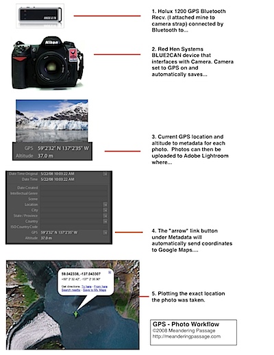
I’m using an internal battery powered Bluetooth GPS Receiver, the HOLUX 1200, and a Red Hen Systems bluetooth BLUE2CAN receiving device that interfaces directly to my camera (Nikon D200). The BLUE2CAN uses the cameras battery.
For convenience, I attach the HOLUX 1200 to my camera strap. You then turn in on before you start to shoot and forget about it
My recent trip to Alaska gave this combo a workout with over-all favorable results. Here some significant notes from my experience:
1. The HOLUX 1200s internal battery lasted on average 8 hours under what I judge severe conditions involving moving in and out of vehicles and limited views of the sky. The HOLUX recharges quickly from a simple USB connection.
2. I didn’t notice any appreciable lessening of the cameras battery life due to the BLUE2CAN.
3. Connection between the HOLUX and BLUE2CAN was overall good but sometimes the HOLUX seemed to be having trouble getting a fix or the BLUE2CAN and HOLUX would take a bit to connect. I don’t know the causes of this. There not much diagnostic data, only a few blinking lights, they’re either connected or not.
4. I estimate that over 80% of the 5,100 photo’s taken on this trip had valid GPS locations captured. I could easily use this existing data to reconstruct the missing locations.
As I said earlier I’m pleased with the results. It was a trial under fire as I was learning about each device while using them. Actually, there wasn’t much time for learning…I was mostly using them. I would expect my results to get better. :-)
I’ve included a basic workflow diagram of the process used to capture, record, and display this locational data with Adobe Photoshop Lightroom and Google Maps.
Note of Interest: The example photo and map view in this workflow go together. The position is correct and was taken in Glacier Bay, Alaska.

